‘One-Stop’ Shop To Learn About Indiana’s Conservation Efforts
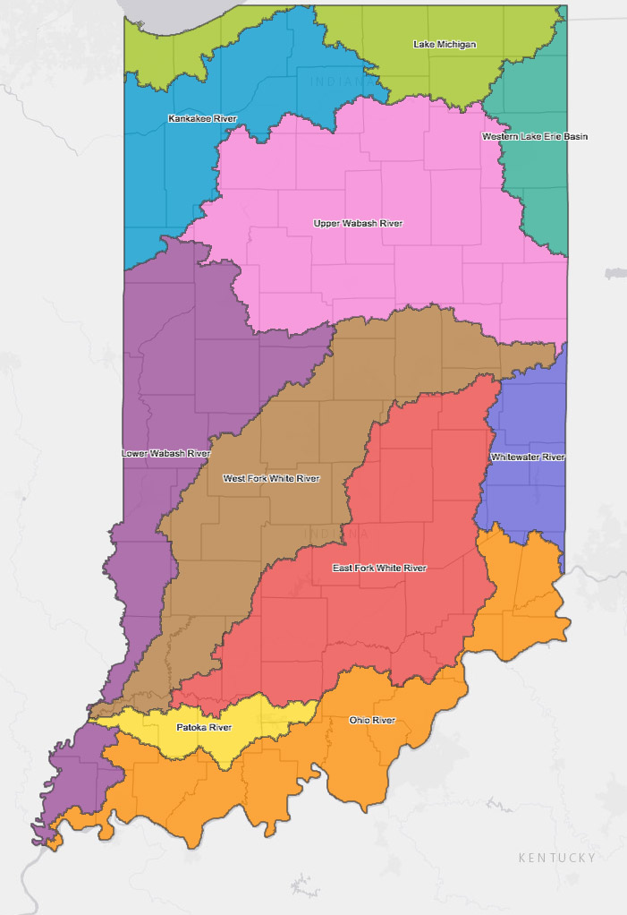
A view of the state’s 10 main river and lake basins
INDIANA — Indiana State Department of Agriculture recently launched an online story map, a one-stop shop for Indiana’s conservation efforts. This map shows the 10 different water basins throughout the state, allowing viewers of the site to click on the respective basins and learn about conservation efforts in those areas.
Kosciusko County is in two river basins: Lake Michigan and the Upper Wabash River basins. By checking out each of these basins, and each of the watersheds within those basins, readers can learn more about conservation efforts. Such information is available as water quality, conservation efforts, soil health, rural residents, urban residents, education, ISDA contact and Indiana’s Nutrient Reduction Strategy.
The northeastern portion of the county is in the St. Joseph-Lake Michigan Watershed, where statistics shows there is 1,088,354 acres, 621,222 acres in agriculture, 203,879 acres having been developed with 215,428 acres in forest or wetlands and 47,826 “other” acres. This watershed also includes a large portion of Elkhart, Steuben and Noble counties and all of LaGrange County.
The remainder of the county is in the Upper Wabash River basin. The majority of the county is in the Tippecanoe Watershed, with a small portion in the Eel River Watershed. Statistics for the Tippecanoe Watershed show this watershed covers 1,246,835 acres, with 966,251 acres in agriculture, and 90,167 acres being developed. There are 165,570 acres hat are forest/wetlands and 24,847 noted as other acres. This watershed also includes a small portion of Noble, Whitley, Marshall and Starke counties, and most of Fulton, Pulaski and White counties.
The Eel River watershed, which covers the southeastern portion of the county, is a total of 521,838 acres, with 397,793 acres in agriculture, 39,278 acres having been developed and 74,121 acres in forest/wetlands. There is 10,646 acres noted as other.
There are two organizations in Kosciusko County — Wawasee Area Conservancy Foundation and The Watershed Foundation — that are also working to conserve soil and water resources. Just like statewide, their efforts are also working.
According to the story map, more than 118 million pounds of sentiment was reduced between 1013-2016 in the St. Joseph-Lake Michigan Watershed; 64 million pounds of sediment reduced in Tippecanoe Watershed, and 87 million pounds in Eel River Watershed.
How does that compare locally?
Heather Harwood, executive director of WACF, reported numerous projects have been implemented in WACF’s 26 year history. The Turkey Creek Watershed includes 74 percent agriculture. Some of these projects will result in or have resulted in more than 13,800 tons of sediment saved from entering the lakes. Thousands of pounds of nitrate and phosphorous have also been reduced filtering into lakes and streams.
WACF has utilized grants totaling more than $1.5 million in specific projects and activities. The grants have been in relationships with the Great Lakes Commission, IDNR Lake and River Enhancement, Elkhart River Restoration Association, along with partnerships with landowners and use of local funds.
The Tippecanoe Watershed is 75 percent agriculture. Lyn Crighton, executive director for TWF, noted in the last four years alone, TWF and partners have invested $820,000 in 95 conservation projects in the Tippecanoe River watershed. This work plus the implementation of 2,566 acres of no-till ad 3,872 acres of cover crops has resulted in the reduction of 60 million tons per year in sediment, along with thousands of pounds of nitrate and phosphorus runoff.
For more information, about the ISDA conservation or to access the conservation story map, visit www.isda.in.gov/2991.htm. To learn more about the WACF visit www.wacf.com and The Watershed Foundation by visiting http://www.watershedfoundation.org.
